 [dhigroup] In cases of accidents or other disastrous events local Fire Brigades or Emergency Management Authorities must prevent, limit, and relieve damages to persons, properties and the environment within
the shortest possible time. Important decisions may often be taken
under uncertainty as readily available information about the area and
the magnitude of the disaster may be incomplete.
GeoFES is a powerful instrument that can support the decision making
both during operations and in connection with pre- and post evaluation
of accidents by operational personal as well as administrative and
managerial staff. Based on GIS technology GeoFES combines spatial
(raster and vector data) and nonspatial data linked to data tables that
contain detailed attribute information, e.g. contact details to
offices, schools, hospitals etc.
It has primarily been developed for preventive fire fighting but may
be equally applicable for other disasters such as explosions, pollution
propagation, flood events etc. GeoFES is applicable in the control
centre, in the commander’s car, and increasingly in all emergency cars.
Some important GeoFES functionalities include:
- Fast localisation of the emergency area. Besides
directly pinpointing to the location on a map there are options for
entering various indirect data for locating the area, e.g. an address,
a road or road crossing or to select specific objects such as schools,
hospitals, high risk buildings etc., or a highway section or a water
body; - Fast publication of all available information including plans and maps over the concerned area or high risk buildings;
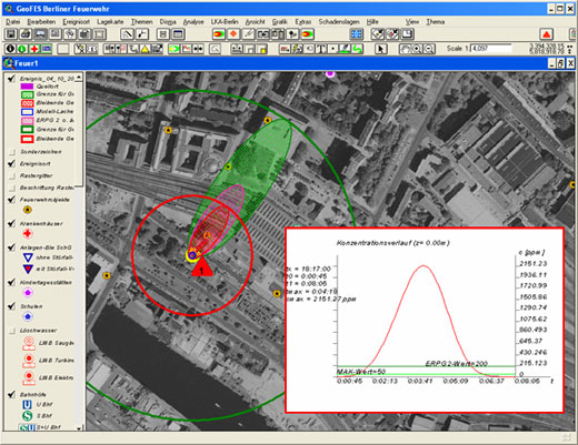
- Identification of threatened areas via
interactive definition of a range or via selection of a certain area,
as for example a district or a local part. GeoFES uses the DISMA
software for simulating the atmospheric spreading of hazardous
materials. Such results are visualized as a polygon on the map and can
be displayed together with other important geographical data of the
analysed area. - Analysis and assessment within the threatened area.
Depending on the amount of available data, complex analyses can answer
important questions such as: Number of inhabitants located within the
hazardous area? Where the nearest hospital and what is is its capacity?
What facilities, schools or other public buildings (including contact person and phone number) are within a certain distance and should be notified? All results can be printed as HTML-protocols. - Operational management of available emergency.
By the integration of tactical graphic symbols resources can be
represented on the map. Additional tabular information may be supplied. - Documentation and logging of the employment
GeoFES is a GIS-based software package using the ArcGIS 9 from ESRI.
The GIS is an excellent platform for carrying out productive emergency
management tasks. Using the GIS platform GeoFES becomes a very flexible
and scalable working environment and can be customized according to
individual needs of the client.
Source: http://www.dhigroup.com/News/NewsArchive/2007/GeoFESDecisionMakingInEmergencySituations.aspx