 [gmes-mariss.com] The MARISS project is the first phase of a pan-European activity to demonstrate the utility and value of integrating information derived from satellite Earth Observation with conventional data streams for improved maritime border control and maritime situation awareness. It is intended to deliver prototype customised information services to national and European government agencies responsible for preventing illegal activities (such as trafficking of persons, drugs, weapons etc) and characterising new threats to European maritime infrastructure and interests. This includes police, border guards, coast guards, intelligence services and national navies as well as appropriate European and international agencies.
MARISS focuses on two categories of service:
* tactical (near real time) monitoring to identify and track suspect vessels in open waters before they reach the European coast. This requires integration of satellite synthetic aperture radar imagery with AIS, VMS, coastal radar and any intelligence data available.
* strategic (longer term) monitoring for threat characterisation. This includes routine monitoring of trafficking routes and detection of suspicious activity in the coastal areas of third countries. The service is based on the analysis of high resolution satellite imagery combined with intelligence information.
MARISS is supported by the European Space Agency (ESA) under the Global Monitoring for Environment Security (GMES)
Objectives
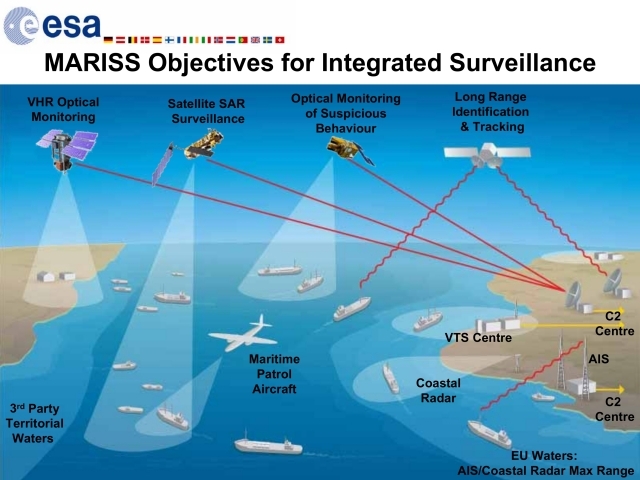
The central objective of MARISS is to characterise the added value from combining information derived from satellite based Earth Observation with conventional data streams such as AIS, coastal radar, maritime patrol aircraft and intelligence sources for maritime border control and maritime situation awareness. This is focussing on two types of service:
* near real time tactical monitoring of vessel movements
* strategic monitoring for anomaly detection and threat characterisation
With respect to near real time tactical monitoring of vessel movements, MARISS is investigating two main components that drive the interest of the target user communities for integrating information derived from satellite Earth Observation data within maritime surveillance and monitoring systems:
* the combination of non-cooperative wide area detection (based on EO imagery) with more limited area cooperative identification systems. This ensures that any tampering (whether accidental or deliberate) with identification systems does not result in a particular vessel being invisible to maritime surveillance authorities.
* the combined coverage of as wide an area as possible using satellite and airborne surveillance systems with coastal systems. This means that limited temporal coverage of open waters by satellite and aircraft can be combined with regular temporal coverage of limited area coastal waters by AIS and coastal radar resulting in a significant improvement to the overall Recognised Maritime Picture.
In addition, it is planned to integrate Long Range Identification and Tracking data when this becomes available. Initial trials based on vessels in open water simulating the LRIT signal will be conducted in early 2008. Finally, under a longer term perspective, options are under investigation for extending the spatial coverage of AIS through the use of satellite based AIS antenna and it is planned to integrate a satellite based AIS data stream once this becomes available during 2008. Integration of additional open source data (eg data available from commercial suppliers such as Lloyds) will also be investigated.
For strategic monitoring and threat characterisation, the combination of different high resolution satellite systems will be investigated. This includes systems that guarantee updated imagery every 24 hours and highly agile systems that can be rapidly tasked to respond to short term information requests.
By demonstrating the impact and benefits from combining EO derived information with conventional systems based on the delivery of the two service areas described above, MARISS is intended to provide clear and credible responses to the following questions in relation to maritime surveillance and control:
* What information is needed?
* What services can be provider?
* What are the benefits and impacts of the proposed service portfolio?
Join Us
MARISS services are beneficial for:
* Military corporations at national level
* Anti-Illegal migration/trafficking national authorities
* Anti-Illegal migration/trafficking police corporations
* Anti-Illegal migration/trafficking local authorities
* National authorities for planning
* Anti Pirate/Terrorism authorities
Mainly organizations dedicated to the control of illegal migration and trafficking.
Do you want to be a member of the MARISS Core Team?
Source: http://www.gmes-mariss.com