 The U.S. Defense Advanced Research Projects Agency says it will research a system to let soldiers overseas access near-live satellite images of their location.
Current satellites cannot provide such information as they are in the wrong orbits and are difficult for troops on the ground to access, experts said.
DARPA’s SeeMe program (Space Enabled Effects for Military Engagements) would create a swarm of inexpensive disposable satellites to allow soldiers on the ground to hit a „see me“ button on a hand-held device such as a smartphone or tablet and receive a satellite image back in less than 90 minutes, NewScientist.com reported Tuesday.
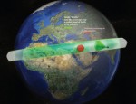
The system would use two dozen small satellites at a cost of $500,000 each that would be in a very low-Earth orbit, covering a band of the planet every 90 minutes and lasting two or three months before burning up on re-entry.
The idea behind the satellites‘ medium-term lifespan and range is to fill a gap between traditional high-orbit imaging satellites and UAVs, unmanned reconnaissance drones, researchers said.
„SeeMe is a logical adjunct to UAV technology, which will continue to provide local or regional very high-resolution coverage, but which can’t cover extended areas without frequent refueling,“ DARPA program manager Dave Barnhart said.
